Every commercial property in Dallas-Fort Worth carries an environmental history. Some of those histories are clean. Many are not. And the ones that aren’t clean rarely announce themselves with visible signs.
As an Environmental Professional conducting Phase I Environmental Site Assessments across the DFW Metroplex, there are specific conditions I evaluate on every property — red flags that, if missed, can expose buyers to significant environmental liability under CERCLA and Texas state law.
These three are the most common, the most frequently overlooked, and the most consequential for commercial real estate transactions in the region.
Red Flag #1: Former Gas Stations Within 1/8 Mile
Underground storage tanks are the single most common source of environmental contamination in Texas commercial real estate. TCEQ’s Leaking Petroleum Storage Tank (LPST) program has documented thousands of release sites across the state — and the Dallas-Fort Worth Metroplex has one of the highest concentrations of registered and deregistered UST facilities in Texas.
The problem isn’t just the gas station on your property. It’s the gas station that was on or near your property — potentially decades ago.
Why USTs leak
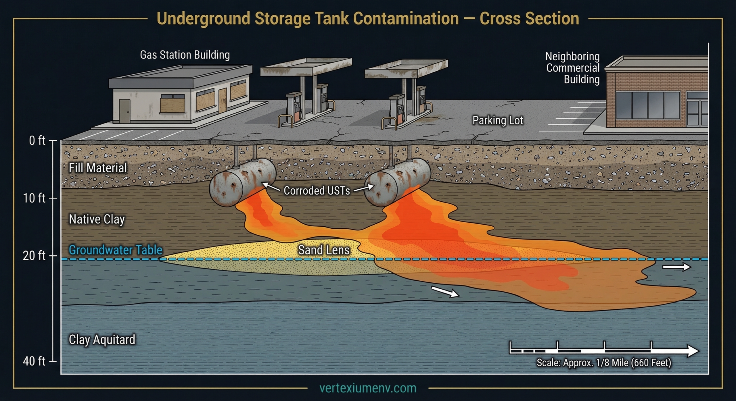
Steel underground storage tanks installed before the late 1980s were not required to have corrosion protection, secondary containment, or leak detection systems. Over time, these single-wall steel tanks corrode from the outside in, developing pinhole leaks that release petroleum product into the surrounding soil. The releases are often slow — gallons per day, not gallons per hour — which means they can continue for years before anyone notices.
How petroleum plumes behave
When petroleum products like gasoline or diesel fuel are released into the subsurface, they don’t stay put. Lighter petroleum fractions (BTEX compounds — benzene, toluene, ethylbenzene, and xylenes) dissolve into groundwater and migrate in the direction of groundwater flow. In DFW’s variable geology, this can mean lateral migration distances of several hundred feet or more, depending on soil type and hydraulic gradient.
The dissolved-phase plume from a leaking UST at a gas station across the street can migrate beneath your property without any visible surface indication. The contamination is entirely subsurface — invisible to a visual inspection, detectable only through soil and groundwater sampling.
What to look for in the Phase I
The Phase I ESA should include a thorough search of TCEQ’s LPST database, the EPA’s Underground Storage Tank database, and historical records (Sanborn maps, aerial photographs, city directories) for any evidence of current or former petroleum storage or dispensing facilities within the ASTM-specified search radius of the subject property. The standard minimum search distance for UST facilities is 1/8 mile (approximately 200 meters).
Critically, not every UST release makes it into the regulatory databases. Tanks that were abandoned in place — pulled from registration without documented removal or closure — represent some of the highest-risk conditions because there’s no closure documentation confirming the tank was properly removed and the surrounding soil was assessed.
Red Flag #2: Pre-1980 Industrial or Manufacturing Use
The regulatory framework that governs hazardous waste management in the United States today didn’t exist before the late 1970s. The Resource Conservation and Recovery Act (RCRA) was enacted in 1976. The Comprehensive Environmental Response, Compensation, and Liability Act (CERCLA) followed in 1980. Before these laws, there were minimal federal requirements for how businesses stored, handled, and disposed of chemicals.
In practical terms, this means that any property in DFW that had industrial or manufacturing tenants before 1980 carries an elevated environmental risk profile — regardless of how the property looks today.
Common pre-RCRA disposal practices
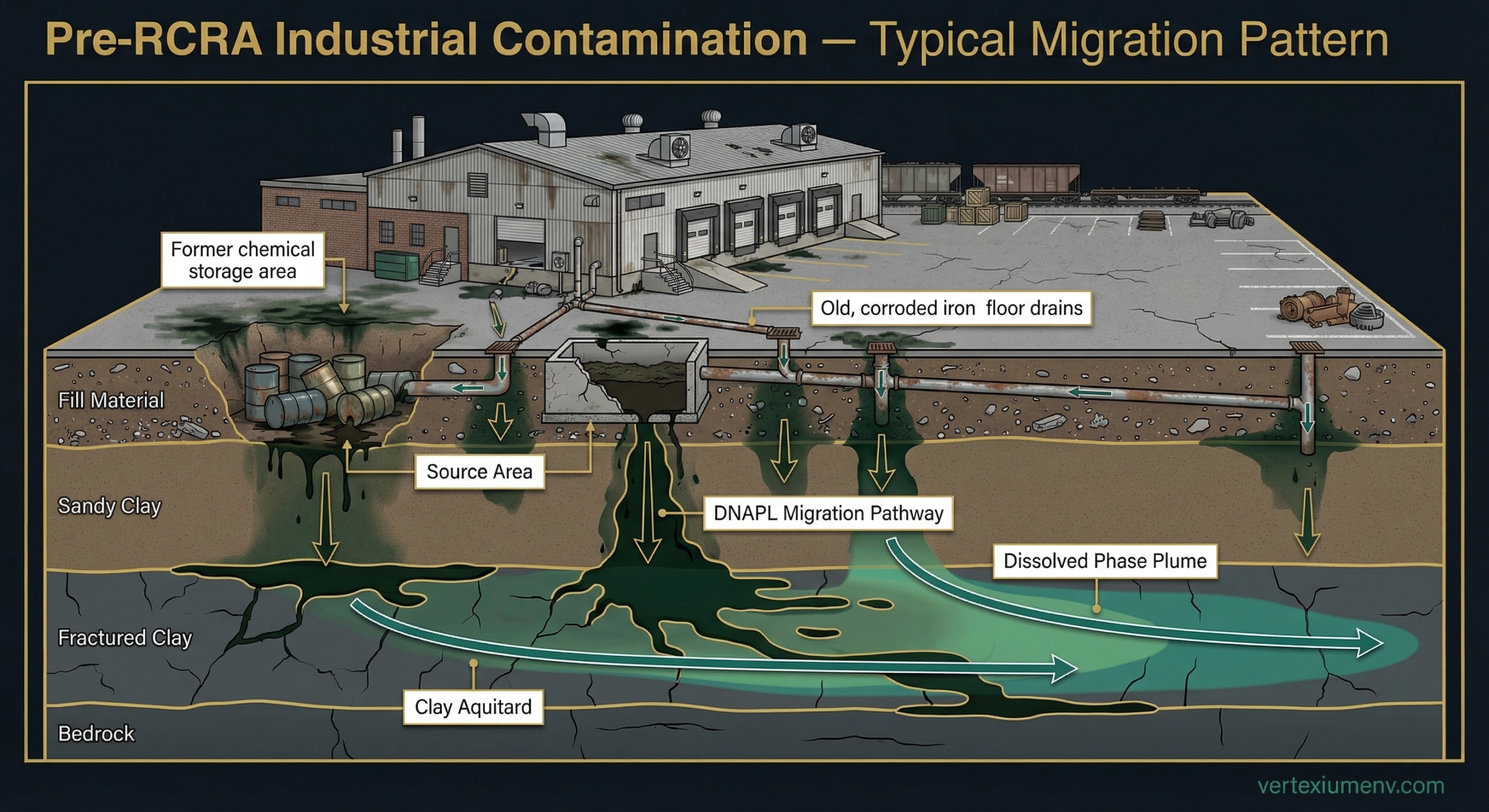
Before RCRA, it was common practice for industrial facilities to:
- Discharge spent solvents, degreasers, and cleaning chemicals directly through floor drains into the subsurface
- Dispose of waste oils and hydraulic fluids in unpaved areas behind buildings
- Bury chemical drums in on-site disposal pits
- Use unlined surface impoundments for liquid waste storage and evaporation
- Burn waste materials in open-air burn pits on the property
These weren’t rogue operations. This was standard industry practice before the regulatory framework existed to prohibit it.
Why chlorinated solvents are particularly concerning
Many industrial operations used chlorinated solvents — trichloroethylene (TCE), perchloroethylene (PCE), 1,1,1-trichloroethane (TCA) — for metal degreasing, parts cleaning, and manufacturing processes. These compounds are dense non-aqueous phase liquids (DNAPLs), meaning they’re denser than water.
When released to the subsurface, DNAPLs sink through the soil column, pass through the water table, and continue migrating downward until they encounter an impermeable layer (such as the clay formations common in DFW’s geology). They pool in low spots and fractures in the clay, creating long-term sources of dissolved-phase contamination that can persist for decades.
A former machine shop or manufacturing facility from the 1960s or 1970s can be the source of a chlorinated solvent plume that’s still actively contaminating groundwater in 2026.
The historical research challenge
Identifying pre-1980 industrial use requires deep historical research — the kind that goes beyond database searches. Historical aerial photographs, Sanborn fire insurance maps, city directory listings, and building permit records are essential tools for reconstructing a property’s operational history. If the Phase I assessment doesn’t research the property’s history back to its first developed use, it may completely miss a former industrial tenant whose operations created the contamination that exists today.
Red Flag #3: Adjacent Railroad Corridors
This is one of the most commonly overlooked recognized environmental conditions in DFW Phase I reports — and it’s one of the most straightforward to identify if the Environmental Professional understands off-site sources of contamination.
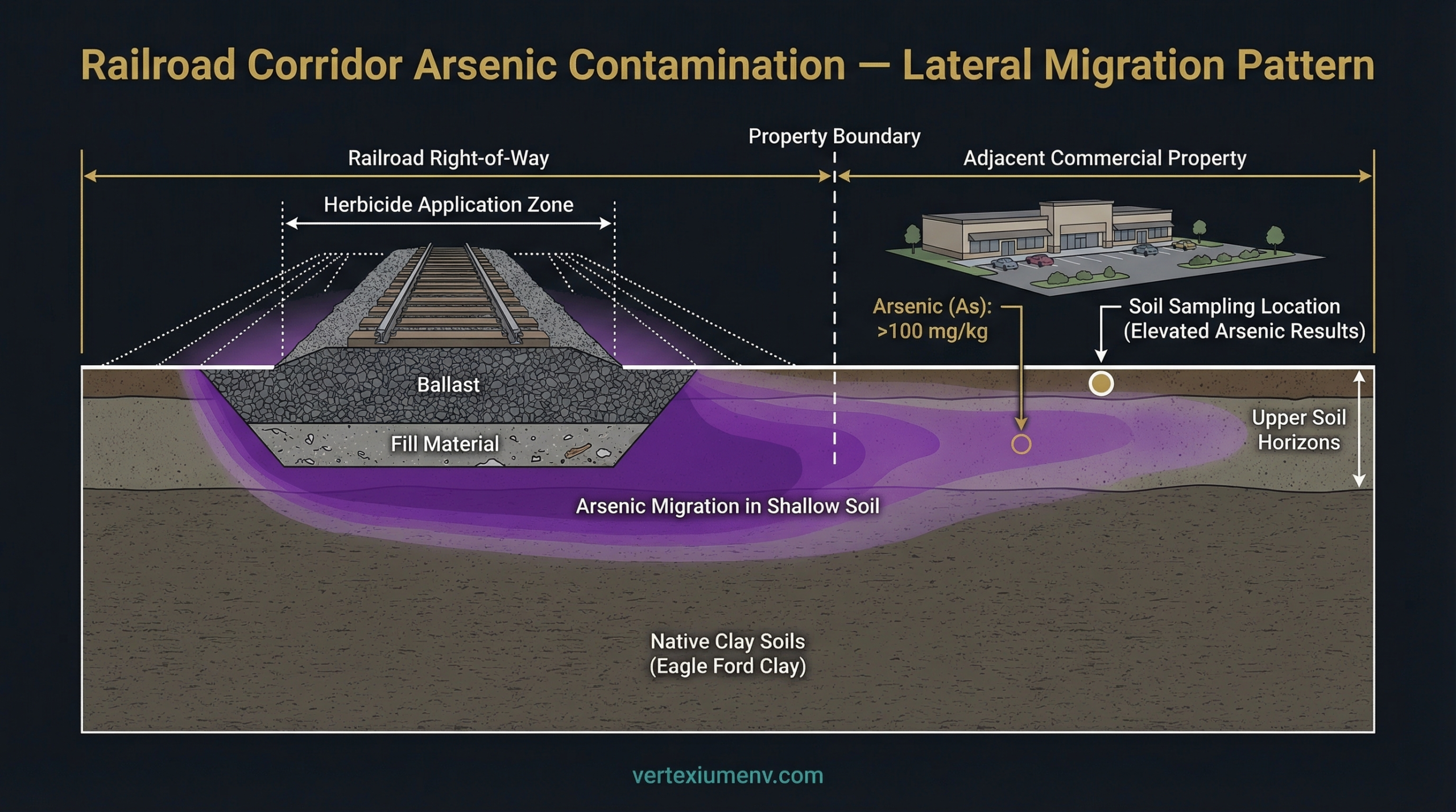
For decades, railroad companies applied arsenic-based herbicides along their rights-of-way to control vegetation growth on and adjacent to the track bed. Sodium arsenite was the most commonly used compound, applied either by spray trucks or from application cars mounted on the rails themselves. The practice was widespread from the early 1900s through the 1980s, when regulatory pressure and the availability of less toxic alternatives led to its phase-out.
How arsenic behaves in DFW soils
Arsenic is an inorganic contaminant that binds strongly to soil particles, particularly in the clay-rich soils common throughout the DFW Metroplex (Eagle Ford clay, Austin Chalk weathered residuum). Unlike petroleum hydrocarbons or chlorinated solvents, arsenic doesn’t readily dissolve and migrate with groundwater. Instead, it tends to concentrate in the shallow soil horizon — typically the top two to four feet — where it was originally deposited.
However, arsenic does migrate laterally through surface runoff, erosion, and soil redistribution. Properties adjacent to active or abandoned railroad corridors frequently show elevated arsenic concentrations in shallow soil that extend well beyond the railroad right-of-way boundary.
Why it’s commonly missed
Railroad arsenic contamination is overlooked in Phase I reports for several reasons:
- It’s an off-site source. The contamination didn’t originate on the subject property, and many environmental professionals focus primarily on on-site conditions.
- It doesn’t show up in standard regulatory database searches. Railroad herbicide application wasn’t a regulated release, so it doesn’t appear in TCEQ’s databases the way a leaking UST would.
- The visual evidence is often absent. Unlike petroleum contamination (which can produce staining, odors, and stressed vegetation), arsenic contamination in shallow soil is invisible to the naked eye.
- The railroad may no longer be active. Abandoned rail corridors can be converted to trails, utility easements, or vacant land — removing the visual cue that a railroad was ever present. Only historical aerial photographs and maps reveal the former rail alignment.
What elevated arsenic means for your transaction
Arsenic contamination in shallow soil is a recognized environmental condition that can affect property value, development options, and transaction timelines. Depending on the concentration levels relative to TCEQ’s Protective Concentration Levels (PCLs) for residential and commercial land use, the presence of arsenic may require:
- A Phase II Environmental Site Assessment to characterize the extent of contamination
- Institutional controls (such as deed restrictions limiting land use)
- Engineering controls (such as capping with clean soil or hardscape)
- Soil removal and off-site disposal in severe cases
None of these are necessarily deal-killers. But all of them have cost implications and timeline impacts that need to be understood before closing.
The Common Thread: These Are Deal-Informers, Not Deal-Killers
The purpose of identifying environmental red flags isn’t to scare buyers away from properties. It’s to ensure that transactions proceed with full knowledge of the environmental conditions — and that the financial implications are understood and accounted for.
A property adjacent to a former gas station with a documented petroleum release can still be an excellent investment — if the buyer understands the contamination, verifies that it’s being addressed through TCEQ’s cleanup programs, and negotiates the purchase price accordingly.
A former industrial facility with subsurface solvent contamination can be redeveloped successfully — with the right environmental assessment, remediation plan, and regulatory pathway (such as TCEQ’s Voluntary Cleanup Program).
A site adjacent to a railroad corridor with elevated arsenic in shallow soil can be developed — with appropriate engineering controls and institutional controls in place.
The difference between a bad deal and a good deal with environmental conditions isn’t the contamination itself. It’s whether you knew about it before you signed.
What This Means for Your Next DFW Property Transaction
If you’re acquiring commercial property in the Dallas-Fort Worth Metroplex, the Phase I Environmental Site Assessment is your first and most important line of defense against environmental liability. But not all Phase I reports are created equal.
The quality of the assessment depends directly on the depth of the historical research, the competence of the Environmental Professional, and their understanding of the specific environmental conditions that characterize the DFW region.
At Vertexium Environmental Solutions, every Phase I ESA we deliver includes comprehensive historical research extending back to first developed use, thorough evaluation of off-site sources of contamination, and the professional judgment of a licensed Professional Engineer with doctoral-level environmental engineering expertise.
Your next property transaction deserves that standard of work. Book a free consultation to discuss your property.
Need Environmental Due Diligence?
Vertexium Environmental Solutions delivers Phase I ESAs with 2-3 week turnaround, fixed-fee pricing, and PhD-level technical review on every report.
Book a Free ConsultationDr. Mohamed Elansary
PhD in Environmental Engineering from Texas A&M University-Kingsville. Licensed Professional Engineer in Texas. Founder of Vertexium Environmental Solutions, delivering Phase I/II ESAs and environmental due diligence for commercial real estate across the DFW Metroplex.