Dallas-Fort Worth is the fourth-largest metropolitan area in the United States, and it is growing faster than almost any comparable market. The pace of commercial real estate development in the Metroplex — new industrial parks in Alliance, mixed-use redevelopment along the DART corridors, suburban expansion through Frisco, McKinney, Celina, and Prosper — has attracted capital from across the country and internationally. Investors who know Chicago industrial or Houston energy sector real estate well are acquiring DFW properties without necessarily understanding the specific environmental characteristics of this market.
That knowledge gap has real consequences. The DFW Metroplex has a distinct environmental profile — shaped by its industrial history, its geology, its regulatory landscape, and the particular patterns of its growth — that experienced commercial real estate professionals need to understand. Environmental conditions that would register as low-risk in one market may require Phase II investigation in DFW because of local factors that aren’t obvious without regional expertise.
As an ASTM E1527-21 Environmental Professional with a PhD in Environmental Engineering from Texas A&M University-Kingsville, and as someone who has conducted Phase I and Phase II Environmental Site Assessments across the DFW Metroplex, I want to walk through the key environmental characteristics of this market that every commercial real estate professional should understand before they close.
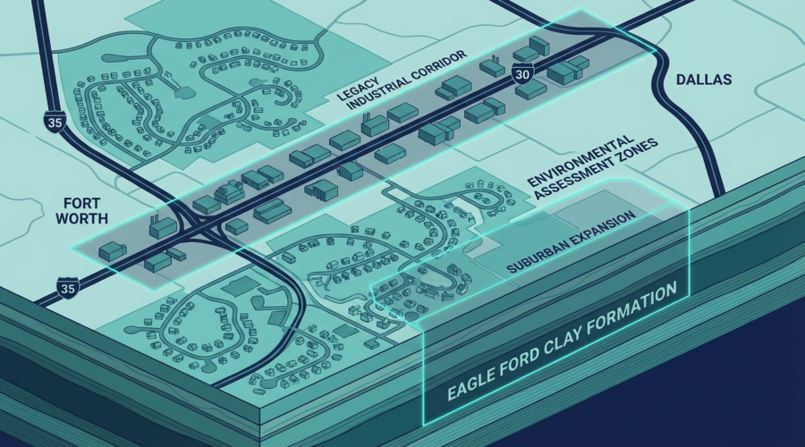
Legacy Industrial Corridors: Where the Environmental Risk Is Concentrated
The DFW Metroplex’s industrial heritage is concentrated along three major interstate corridors that were the economic arteries of 20th-century Texas: I-30 (running east-west through Dallas and Fort Worth), I-35 (the north-south spine splitting into I-35E through Dallas and I-35W through Fort Worth), and I-45 (the southeastern corridor connecting Dallas to Houston).
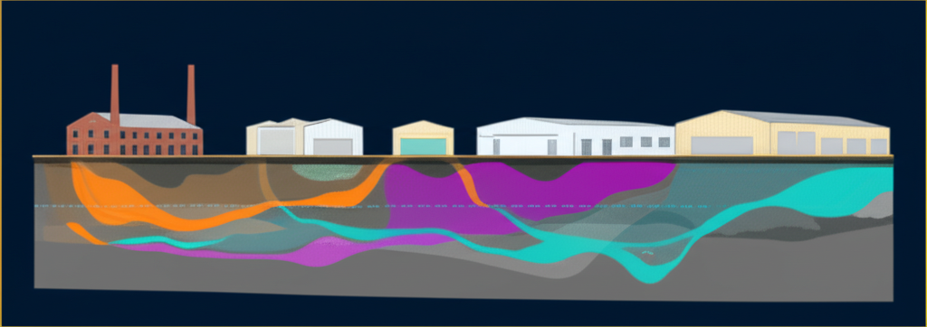
These corridors were home to the manufacturing, chemical processing, printing, metalworking, and distribution operations that built the Metroplex economy from the 1940s through the 1980s. The industrial districts adjacent to these interstates — south Dallas along I-30/I-45, west Dallas along I-30, east Fort Worth and the Meacham corridor along I-35W, the industrial areas of Grand Prairie and Irving between the two cities — accumulated decades of environmental conditions that are still present in the subsurface today.
South Dallas and East Dallas Industrial Corridors
The area bounded roughly by I-30, I-45, and Loop 12 in south Dallas contains some of the highest concentrations of legacy industrial sites in the Metroplex. Former manufacturing facilities, railroad yards, chemical distributors, and metal processing operations operated in this area for decades — many before the regulatory framework that now governs hazardous waste disposal existed. The TCEQ Documented Industrial Hazardous Waste (IHW) database and the EPA’s CERCLIS database both list significant numbers of sites in this corridor.
For commercial real estate investors acquiring property in this area — particularly as redevelopment pressure from downtown Dallas pushes southward — Phase I investigations consistently identify former industrial uses that warrant Phase II investigation. Environmental conditions in this corridor should not be assumed to be addressed by redevelopment activity alone; subsurface conditions reflect historical operations regardless of what has been built above them.
West Dallas
West Dallas has seen dramatic investment and redevelopment over the past decade, driven by its proximity to downtown, Trinity Groves, and the Margaret Hunt Hill Bridge. The neighborhood’s transformation has been remarkable — but its industrial history has not disappeared from the subsurface. West Dallas was home to smelting operations, battery recycling facilities, and a range of light industrial uses whose legacy includes lead contamination in soil that has been the subject of extensive regulatory and litigation activity.
Properties in West Dallas require particularly thorough historical research and evaluation of regulatory databases for TCEQ and EPA actions. The area’s contamination history is well-documented, which means Phase I investigations can identify specific site histories — but this also means buyers need to engage with that history rather than assuming it’s been resolved.
Fort Worth Industrial Districts
Fort Worth’s industrial history is concentrated east of downtown along I-30 and in the Meacham corridor north of the city. The historic Stockyards area and adjacent meatpacking district have their own environmental legacy — rendering operations, hide processing, and meat packing generated significant waste streams for decades. Former rail yards in the area introduce the standard railroad corridor concerns (arsenic from herbicide application, petroleum products from fueling operations).
Rapid Suburban Expansion: The Former Agricultural Land Problem
While the legacy industrial corridors represent well-understood environmental risk categories, the rapid suburban expansion in northern Collin and Denton counties presents a different and sometimes underappreciated risk profile: former agricultural land.
Cities like Frisco, McKinney, Allen, Prosper, Celina, and Anna have absorbed enormous commercial real estate development over the past 15 years. Much of this development occurred on land that was agricultural — cotton, grain sorghum, and hay production, along with cattle grazing — as recently as the early 2000s. Agricultural land use creates specific environmental conditions that often go undetected without thorough historical research:
Pesticide and Herbicide Residues
Commercial agricultural operations in North Texas historically used organochlorine pesticides (DDT, chlordane, dieldrin, endrin, heptachlor) and organophosphate compounds that persist in shallow soils decades after application ceased. DDT, though banned for agricultural use in 1972, has a soil half-life measured in years, and parent compound and metabolite (DDE, DDD) concentrations can persist in shallow soils from pre-ban applications. These compounds can be present in concentrations that exceed TCEQ’s Protective Concentration Levels (PCLs) for unrestricted land use without any visible surface evidence.
On-Site Fuel Storage
Agricultural operations require large quantities of diesel fuel for equipment, often stored in above-ground or underground tanks that were never registered with TCEQ. Farm fuel tanks — commonly 500-gallon to 2,000-gallon underground steel tanks — were ubiquitous on working farms and are frequently encountered during Phase II investigation of former agricultural parcels. These tanks were typically installed without documentation, operated without compliance monitoring, and abandoned in place rather than removed when the land changed use.
Chemical Storage and Application Areas
Pesticide mixing areas, chemical storage buildings, and equipment washing areas on agricultural properties create point-source contamination that can be highly concentrated in relatively small areas. These areas are often identifiable from aerial photographs as paved or concrete-surfaced areas adjacent to barns or equipment sheds — but they may not be identifiable on the current site without historical photograph review.
Eagle Ford Clay and Austin Chalk: Understanding DFW’s Geology
The environmental assessment of any DFW property must account for the region’s distinctive geology, which controls how contaminants behave in the subsurface. Two formations dominate the geology of the Metroplex and profoundly influence contaminant migration:
Eagle Ford Clay (Shale)
The Eagle Ford Formation underlies much of Dallas and portions of Tarrant and Collin counties. At the surface, it weathers to produce the dark, sticky clay soils — locally called “black gumbo” — that DFW residents know intimately for their foundation-cracking, flood-prone behavior. From an environmental perspective, Eagle Ford clay has important characteristics:
- Low permeability — Contaminants move very slowly through undisturbed Eagle Ford clay, which can limit the lateral spread of contamination but also means that once contamination is established in the clay, it’s extremely difficult to remediate.
- Desiccation cracking — Eagle Ford clay undergoes dramatic volume changes with moisture content. When dry, it develops deep vertical fractures that provide preferential pathways for contaminant migration — effectively short-circuiting the low-permeability matrix. This behavior makes contamination transport in Eagle Ford clay highly unpredictable: low matrix permeability but potentially high effective permeability along fractures.
- Contaminant sorption — Clay minerals strongly sorb certain contaminants (particularly cationic metals and some organics), which can retard migration but also creates long-term contaminant reservoirs that resist remediation.
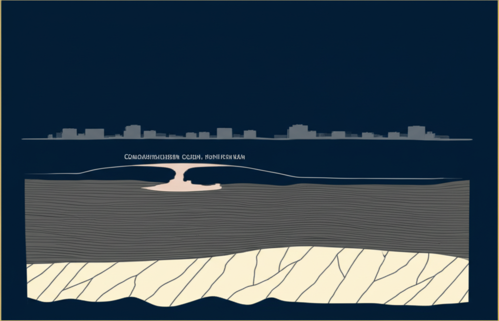
Austin Chalk
Beneath the Eagle Ford, and exposed at the surface in western Dallas and much of the Fort Worth-Tarrant County area, is the Austin Chalk limestone. Austin Chalk has a very different character:
- Fractures and solution channels — The Austin Chalk is a fractured carbonate rock with secondary porosity created by dissolution of calcium carbonate over geologic time. These fractures and solution channels create preferential groundwater flow pathways that can move contaminants rapidly and in directions that don’t follow topographic gradients.
- High groundwater velocity in fractures — Groundwater in Austin Chalk fractures can move at rates orders of magnitude faster than groundwater in the surrounding matrix. A contaminant released at a property in a Fort Worth area with Austin Chalk at depth can migrate hundreds of feet in groundwater within months.
- Difficult to characterize — The location and orientation of Austin Chalk fractures is difficult to predict without site-specific investigation. This uncertainty makes Phase II investigations in Austin Chalk terrain particularly challenging and requires an experienced Environmental Professional who understands the geology.
The TCEQ Regulatory Landscape in DFW
Understanding the TCEQ regulatory framework is essential for commercial real estate professionals operating in Texas. TCEQ maintains several databases that are critical to Phase I investigation and that represent the regulatory backdrop for environmental conditions in the DFW market:
LPST Database (Leaking Petroleum Storage Tanks)
The LPST database is one of the most densely populated regulatory databases in the Metroplex. It lists petroleum storage tank release sites — properties where a confirmed or suspected release from a UST or AST has been documented. There are thousands of open and closed LPST sites in DFW. For any commercial property within 1/8 mile of a gas station — current or former — the LPST database is essential reading.
Critically, a closed LPST case doesn’t necessarily mean the contamination is gone. TCEQ closes LPST cases when concentrations meet cleanup standards — but those standards are use-specific, and a case closed to commercial standards may still have residual contamination above residential or industrial cleanup thresholds.
IHW Database (Industrial and Hazardous Waste)
The IHW database documents facilities that have reported hazardous waste generation, storage, treatment, or disposal. IHW listings in the database indicate a facility’s regulatory status but do not necessarily confirm contamination. The significance of an IHW listing depends on the types of waste generated, the facility’s compliance history, and whether any release incidents have been documented.
VCP Database (Voluntary Cleanup Program)
TCEQ’s Voluntary Cleanup Program (VCP) is a significant regulatory mechanism in DFW because it provides a defined pathway for addressing contamination on properties that would otherwise carry open regulatory liabilities. Properties in the VCP database are actively being investigated and remediated under TCEQ oversight, which provides both a status indicator and a liability-management framework for buyers who are willing to engage with the process.
ECOS/EDGE Environmental Databases
TCEQ’s ECOS and EDGE systems consolidate regulatory records for air, water, and waste programs. These databases are essential for identifying facilities with environmental compliance records that may indicate potential release conditions — even where no formal release site has been documented.
What This Means for Your Next DFW Acquisition
The DFW environmental landscape is not monolithic. A property in legacy south Dallas industrial corridor requires a different assessment emphasis than a former agricultural parcel in Prosper. A property underlain by Eagle Ford clay behaves differently from one in the Austin Chalk terrain of western Fort Worth. A site within 1/8 mile of a former gas station in Garland carries different risk than a suburban office park in Allen.
Effective environmental due diligence in DFW requires an Environmental Professional who understands this regional context — not a generic Phase I template applied uniformly across markets. The assessment must be calibrated to the specific historical, geological, and regulatory characteristics of the Metroplex.
At Vertexium Environmental Solutions, our Phase I ESAs reflect deep familiarity with DFW’s industrial history, geology, and regulatory landscape. We don’t apply a Houston or Austin lens to Dallas-Fort Worth properties — we assess them with the regional knowledge they require.
Our Phase I and environmental due diligence packages are scoped to the property. Contact us at vertexiumenv.com/contact.html to discuss what your specific DFW property acquisition requires.
Need Environmental Due Diligence?
Vertexium Environmental Solutions delivers Phase I ESAs with 2-3 week turnaround, fixed-fee pricing, and PhD-level technical review on every report.
Book a Free ConsultationDr. Mohamed Elansary
PhD in Environmental Engineering from Texas A&M University-Kingsville. Founder of Vertexium Environmental Solutions, delivering Phase I/II ESAs and environmental due diligence for commercial real estate across the DFW Metroplex.